About
Double Gorilla Trekking: Combining Rwanda and Uganda for the Ultimate Primate Experience
Mountain gorilla trekking ranks among the most profound wildlife encounters available anywhere on earth, and for travellers who have the time and resources, doing it twice—once in Rwanda’s Volcanoes National Park and once in Uganda’s Bwindi Impenetrable Forest—offers an experience that single-country itineraries simply cannot match. This practice, often called “double gorilla trekking,” has grown increasingly popular among serious wildlife enthusiasts, photographers, and conservation-minded travellers who recognise that these two countries, despite hosting the same endangered species, offer fundamentally different encounters shaped by distinct landscapes, gorilla family dynamics, and trekking conditions.
What Double Gorilla Trekking Actually Involves
Double gorilla trekking simply means purchasing two separate gorilla permits and undertaking two distinct treks, typically within the same trip, one in each country. Rwanda’s permits are issued by the Rwanda Development Board and currently cost considerably more than Uganda’s, which are managed by the Uganda Wildlife Authority. Travellers usually base themselves near Volcanoes National Park for several days, complete one or two treks there, then cross the border (often via the Cyanika or Katuna crossing points) into southwestern Uganda to trek again in Bwindi, sometimes adding a visit to the smaller Mgahinga Gorilla National Park as well. The entire circuit can be completed in a week to ten days, though many operators recommend a more relaxed pace of two weeks to properly absorb both regions and avoid the fatigue that comes with back-to-back forest hikes at altitude.
The logistics are more straightforward than one might expect. The Rwanda-Uganda border crossing near Kisoro is well-trodden by tour operators, and most companies specialising in gorilla trekking run regular transfers between the two park regions. Travel time between Volcanoes National Park and Bwindi Impenetrable Forest is typically three to five hours by road, depending on which sector of Bwindi serves as the destination.
Why Travellers Should Choose Double Treks
The case for doing both treks rather than just one rests on several distinct arguments, and prospective trekkers should weigh each carefully against their budget, fitness, and time constraints.
Different gorilla families, different personalities. Mountain gorillas are organised into distinct family groups, each with its own dominant silverback, social structure, and behavioural quirks. A trek in Rwanda might place visitors with a large, settled troop accustomed to decades of habituation, while a Ugandan trek could introduce them to a smaller, more recently habituated family still displaying more dynamic or unpredictable behaviour. No two encounters are alike, and repeating the experience in a different park all but guarantees a genuinely new encounter rather than a repetition of the first.
Contrasting landscapes and trekking experiences. This is perhaps the strongest argument for doing both. Rwanda and Uganda, though geographically close and home to the same species, offer markedly different physical environments for trekking, which fundamentally change the character of the hike itself, the photography conditions, and the overall sensory experience. A trekker who has only experienced one park has only seen half the story of how varied mountain gorilla habitat can be.
Conservation impact across both nations. Permit fees fund anti-poaching patrols, veterinary care for the gorillas, and community development programs in the areas surrounding both parks. By trekking in both countries, visitors spread their financial contribution across two national conservation programs and two sets of local communities that depend heavily on tourism revenue, broadening their positive impact on the broader Virunga-Bwindi gorilla conservation landscape rather than concentrating it in a single location.
Comparative cultural and touristic experiences. Rwanda and Uganda, while neighbours, have markedly different national characters, infrastructure, and tourism cultures. Rwanda offers polished roads, the moving Kigali Genocide Memorial, and a notably orderly, security-conscious atmosphere. Uganda offers a rawer, more rugged travel experience, often paired with additional wildlife opportunities such as chimpanzee tracking in Kibale Forest, white-water rafting on the Nile, or a safari in Queen Elizabeth National Park. Combining both countries gives travellers a fuller picture of East African travel rather than experiencing just one national context.
Photography and memory diversity. For photographers in particular, the differing vegetation density, light conditions, and terrain between the two parks produce strikingly different images. Bwindi’s name—”impenetrable”—is earned, and photographs taken there often feature gorillas emerging from dense, tangled undergrowth, while Volcanoes National Park’s more open bamboo and Hagenia forests can yield clearer compositional opportunities with the dramatic volcanic peaks as a backdrop.
Insurance against a disappointing trek. Though rare, treks can occasionally be less rewarding due to gorilla family movement, weather, or limited viewing time. Doing two treks in two locations reduces the chance that a single underwhelming experience defines the entire trip, and it builds in redundancy for what is, for many, a once-in-a-lifetime or bucket-list undertaking.
That said, double trekking is not for everyone. The financial cost is substantial, since Rwanda’s permits alone run into four figures in US dollars, and Uganda’s add a significant secondary expense, plus border crossing logistics, additional accommodation, and extra trekking days. Physically, consecutive treks at altitude across multiple days can be demanding, particularly for older travellers or those not accustomed to strenuous hiking. Anyone considering the double trek should honestly assess their fitness, budget, and appetite for two long days of forest hiking rather than treating it as an automatic upgrade.
The Topography of Volcanoes National Park, Rwanda
Volcanoes National Park, known locally as Parc National des Volcans, sits in northwestern Rwanda and forms part of the larger Virunga Massif, a chain of volcanoes shared across the borders of Rwanda, Uganda, and the Democratic Republic of Congo. The park derives both its name and its dramatic character from this chain, which includes eight major volcanic peaks, five of which lie at least partially within Rwandan territory: Karisimbi, Bisoke, Muhabura, Gahinga, and Sabyinyo. Karisimbi, the tallest, rises to roughly 4,507 meters, making it the highest point in Rwanda and giving the park an alpine character quite different from typical tropical forest reserves.
This volcanic origin shapes nearly everything about the park’s topography. The terrain is steep and irregular, formed by lava flows, ash deposits, and the slow buildup of volcanic material over thousands of years, leaving the ground uneven, often muddy, and riddled with hidden depressions, gullies, and exposed roots. Trekkers typically begin their hikes from the park’s lower boundary at elevations around 2,400 to 2,500 meters and may climb several hundred meters further depending on where the gorilla family being tracked happens to be located that day, since gorillas range widely across the slopes and their position is monitored daily by trackers who head out ahead of tourist groups.
The vegetation across Volcanoes National Park changes in distinct bands as elevation increases, a phenomenon known as altitudinal zonation. At the lower elevations near the park boundary, dense bamboo forest dominates, covering roughly a third of the park’s total area and providing critical seasonal feeding grounds for gorillas, who consume bamboo shoots avidly when they are in season. Climbing higher, the bamboo gives way to Hagenia-Hypericum woodland, an open-canopy forest dominated by twisted, moss-draped Hagenia abyssinica trees that create a strikingly atmospheric, almost fairy-tale environment with dappled light filtering through gnarled branches. Higher still, near the volcanic peaks themselves, the vegetation transitions into Afro-alpine zones featuring giant lobelias, groundsels, and eventually bare volcanic rock and moorland, though gorilla treks rarely venture into these uppermost zones since the gorillas themselves favour the bamboo and Hagenia belts where food is more abundant.
Because the underlying terrain is volcanic rather than the dense rainforest one might expect, the going underfoot, while still strenuous, tends to be somewhat more open in places, with less of the tangled undergrowth that characterises Bwindi. However, this should not be mistaken for an easy hike. The slopes are steep, the altitude is significant enough to cause breathlessness in unacclimatized visitors, and frequent rain transforms volcanic soil into slick, energy-sapping mud. Weather in the park is highly changeable, with the volcanic peaks often shrouded in cloud and mist, contributing to a cool, damp climate despite the park’s equatorial location; temperatures at altitude can feel surprisingly cold, particularly in early mornings.
The Virunga volcanoes are also geologically active in parts, with two of the peaks within the broader massif (across the DRC border) still considered active volcanoes, though those within Rwanda’s portion of the park are dormant. This volcanic legacy has produced exceptionally fertile soils on the lower slopes outside the park boundary, which is why the surrounding agricultural land is so densely cultivated and densely populated, creating a striking visual contrast between the wild, forested slopes within the park and the terraced farmland immediately outside its edge.
The Topography of Bwindi Impenetrable Forest, Uganda
Bwindi Impenetrable National Park, located in southwestern Uganda along the edge of the Albertine Rift Valley, presents an entirely different topographical character from its Rwandan counterpart. Rather than being volcanic in origin, Bwindi is one of the oldest and most biodiverse rainforests in Africa, believed to have survived relatively undisturbed through the last Ice Age, which has allowed it to develop extraordinary species diversity, including over 400 plant species, numerous endemic birds, and, of course, its population of mountain gorillas alongside other primates.
The park’s terrain is defined by a dense network of steep hills and narrow valleys, with elevations ranging from approximately 1,160 meters in the valley bottoms to around 2,600 meters at the highest ridgelines. This range of elevation, combined with the rugged, hilly topography, makes for genuinely challenging trekking, often considered more physically demanding than trekking in Volcanoes National Park, despite the somewhat lower maximum altitude. The constant up-and-down nature of the terrain, navigating steep ridges and descending into valleys only to climb again, means that trekkers can cover relatively short straight-line distances while expending considerable energy.
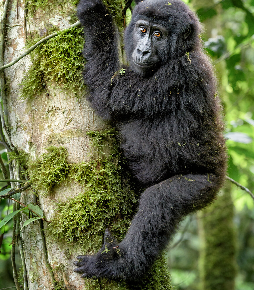
True to its name, the forest itself is extraordinarily dense. Centuries of undisturbed growth have produced a tangled, multi-layered canopy with thick undergrowth, vines, ferns, and a profusion of plant life that makes off-trail movement genuinely difficult, hence the “impenetrable” designation given by early colonial-era visitors. Trackers and ranger guides often need to cut paths through vegetation using machetes when gorilla families have moved into particularly dense sections, and visitors should expect to push through tangled foliage, climb over fallen logs, and navigate slippery, root-covered slopes throughout the trek.
Unlike the more clearly banded vegetation zones of Volcanoes National Park, Bwindi presents a more uniformly dense tropical montane forest throughout most of its accessible trekking areas, though the park does contain some variation, with drier, more open patches in certain sectors and wetter, denser growth in others, particularly in the southern part of the park around Rushaga and Nkuringo. The soil tends to be rich and dark, often slick with moisture given the region’s high rainfall, and the forest floor is frequently obscured by thick leaf litter and undergrowth that conceals uneven ground, adding to the physical challenge of the hike.
Bwindi is divided into four main trekking sectors—Buhoma, Ruhija, Rushaga, and Nkuringo—each with somewhat different terrain characteristics and habituated gorilla families. Rushaga and Nkuringo, in the park’s south, are generally regarded as having steeper, more demanding terrain, while Buhoma in the north offers comparatively gentler access, though “gentler” remains a relative term in a park where genuinely flat ground is scarce. The dense canopy throughout most of the park also means that light levels are lower than in Rwanda’s more open Hagenia woodlands, a factor photographers should anticipate.
Bwindi’s climate is characteristically tropical, humid, and prone to frequent rainfall throughout the year, with two distinct wetter seasons. The combination of high humidity, dense vegetation, and frequent rain produces the muddy, slippery conditions for which Bwindi treks are well known, and visitors are universally advised to wear sturdy, waterproof hiking boots and gaiters.
Conclusion
For travellers able to commit the time and budget required, double gorilla trekking across Rwanda and Uganda offers a richer, more textured understanding of mountain gorilla habitat than either park can provide alone. The volcanic slopes and banded vegetation zones of Volcanoes National Park, with their dramatic peaks and relatively more open Hagenia woodlands, stand in deliberate contrast to the ancient, tangled, hill-and-valley rainforest of Bwindi. Encountering gorilla families in both settings not only doubles the chance of a profound wildlife encounter but also deepens appreciation for the ecological diversity that has allowed these endangered great apes to persist across two such different, equally precious, landscapes.
Mountain gorillas (Gorilla beringei beringei) are one of the most extraordinary wildlife encounters on Earth, and gorilla trekking has become a signature safari experience in East Africa for good reason.
Where They Live
Mountain gorillas exist in only two isolated populations, found nowhere else on the planet:
- The Virunga Massif — spanning the borders of Uganda, Rwanda, and the Democratic Republic of Congo, including Volcanoes National Park (Rwanda), Mgahinga Gorilla National Park (Uganda), and Virunga National Park (DRC)
- Bwindi Impenetrable Forest — a dense, ancient rainforest in southwestern Uganda
They live at high altitude, typically between 2,200 and 4,300 meters, in cool, misty mountain forests thick with bamboo and vegetation.
A Conservation Success Story
Mountain gorillas were once considered critically endangered, with numbers dropping below 700 individuals in the late 1980s. Thanks to decades of dedicated conservation work, anti-poaching efforts, and community-based tourism, the population has slowly recovered to just over 1,000 individuals today — one of the only great ape populations in the world that is actually increasing. This recovery is largely credited to the revenue and protection that gorilla trekking tourism generates.
Why It’s Such a Popular Safari Activity
1. Rarity and exclusivity. With only around 1,000 gorillas left and permits deliberately limited (a handful of groups per day, per park), trekking offers an experience very few people on Earth get to have. That scarcity — plus permit costs running from a few hundred to $1,500+ depending on the country — adds to its appeal as a bucket-list activity.
2. Profound closeness with a wild great ape. Habituated gorilla families allow visitors to sit within a few meters of them for a full hour, watching silverbacks, mothers, and playful youngsters go about their day. The eye contact and clear intelligence in their gaze often leaves people deeply moved — many describe it as the most emotional wildlife encounter of their lives.
3. The adventure of the trek itself. Reaching the gorillas isn’t passive — it involves hiking through dense, muddy, high-altitude rainforest, sometimes for a couple of hours, sometimes much longer. The physical effort and unpredictability make the eventual encounter feel earned.
4. Direct conservation impact. Because permit fees fund park protection and local communities, visitors know their trip is directly supporting the survival of an endangered species — a rare case where tourism dollars visibly translate into conservation outcomes.
5. Combines well with other iconic experiences. Uganda and Rwanda pair gorilla trekking with chimpanzee tracking, savanna game drives, and volcano hikes, letting travelers build a broader East African itinerary around it.
If you’re considering it, permits typically need to be booked well in advance (especially in Rwanda, where demand is highest), and July is actually within one of the better trekking windows since the dry season runs roughly June through September.